624 Squadron Scholarship Winner Rosie Stevenson’s Mission
Rosie Stevenson was the 624 Squadron Special Mission Scholarship winner last year, earning the opportunity to undertake an exciting flying mission. While she had ambitious plans for her scholarship flight, her focus this year shifted towards an equally exciting challenge: progressing with her commercial pilot training. Rosie shares her aviation journey and how her passion for flying continues to shape her future ambitions.
The Challenge – Introduction
The planned challenge involved flying to 12 airfields in 12 hours, raising awareness of mental health within the aviation industry, and to raise money for an aviation focused mental health charity. The challenge was centred around the statistic that 12.6% of commercial pilots fall into the threshold for clinical depression, highlighting the importance of recognising, understanding and supporting mental health issues within the industry.
Mental health within pilots received major attention following a Germanwings Airbus A320-211 crash in 2015. Scheduled from Barcelona (Spain) to Dusseldorf (Germany), flight 4U9525 crashed into terrain 100km north-west of Nice, killing all 150 souls on board (144 passengers, 4 cabin crew and 2 pilots). The crash was an intentional act by the first officer, Andreas Lubitz, who had been treated for suicidal tendencies which declared him unfit to work by his doctor. Lubitz should’ve taken this declaration to his employer; however he continued to report for duty, which due to German laws at the time meant the employer was unaware of his mental state. In the aftermath of this crash, a few studies were created, examining the issue surrounding mental health among pilots. This is an incredibly difficult subject to research, as participants may be reluctant to disclose symptoms for fear of losing or having restrictions placed on their medical. This creates the possibility that research may underestimate the true prevalence of mental health conditions within the profession.
This is why in a Harvard library study Airplane pilot mental health and suicidal thoughts: a cross-sectional descriptive study via anonymous web-based survey, the anonymity was a priority. This study found that 12.6% of airline pilots met the clinical depression threshold, increasing to 13.6% of pilots who worked within the 30 days prior to survey completion. This is significantly higher than the 2025 statistic of 5.7% of adults globally suffering from depression. Although differences in study methodology and populations must be considered in this comparison, the findings underline the importance of addressing mental health within aviation.
The planned route covered airfields from near the east coast of England towards the Welsh border, stopping at airfields throughout the Midlands in between. The plan was to incorporate a combination of full-stop landings and touch-and-goes. The airfields and the timings linked to them were planned so that I would have enough time for the airfields preferred join, while also allowing me time to rest and eat at those I selected to do a full stop at.
The Planned Route
- Depart Cambridge (EGSC) at 0845
- Full Stop Turweston (EGBT) at 0935
- Depart Turweston (EGBT) at 1005
- Touch & Go Oxford (EGTK) at 1040
- Touch & Go Gloucester (EGBJ) at 1110
- Full Stop Wellesbourne (EGBW) at 1135
- Depart Wellesbourne (EGBW) at 1135
- Touch & Go Wolverhampton Halfpenny Green (EGBO) at 1240
- Touch & Go Tatenhill (EGBM) at 1305
- Touch & Go Leicester (EGBG) at 1340
- Full Stop Connington (EGSF) at 1415
- Depart Connington (EGSF) at 1500
- Touch & Go Old Buck (EGSV) at 1545
- Touch & Go Seething (EGSJ) at 1600
- Touch & Go Duxford (EGSU) at 1650
- Full Stop Cambridge (EGSC) at 1705
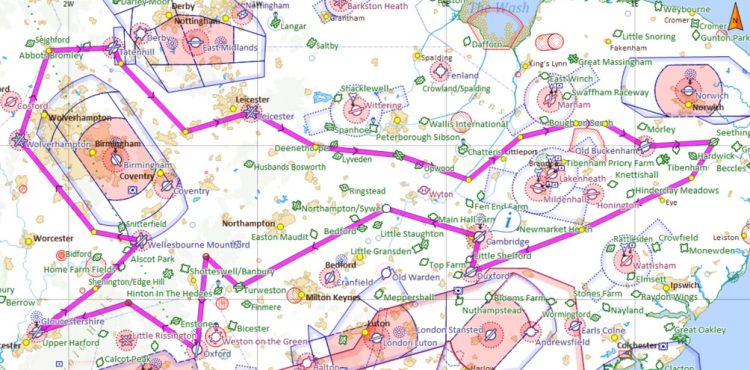
For each touch and go, I added 5-15 minutes to the calculated en-route time to allow for joining procedures and time in the circuit. Many of the smaller airfields preferred an overhead join, whereas the larger ones would accommodate and sometimes preferred a straight-in approach. However, they were more likely to request me to hold for inbound instrument traffic and were stricter with arrival time slots.
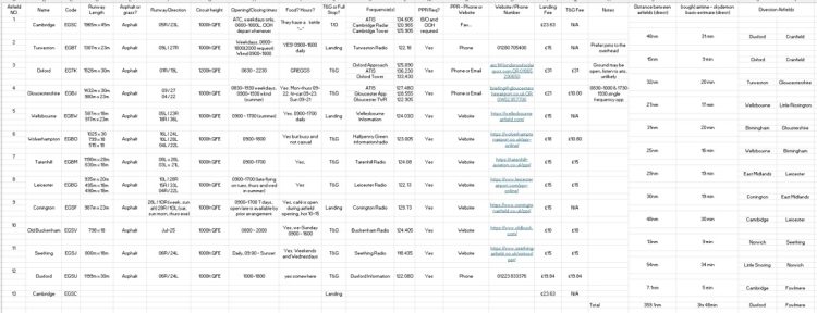
Given how long and complex this challenge was going to be, in-depth planning was essential. To keep this all organised, I made a spreadsheet with all the information I may need, such as runway length and width, runway surface type, operating hours, preferred PPR method, frequencies, and more. Having this information in one place made it easier to identify important information at a glance.
The Week Running Up
Before beginning preparation, I had flown once in 2026 as pilot in command in a single engine aircraft. This flight was a 6 monthly refresher with an instructor back in May. I had also completed a handful of training flights in a multi-engine aircraft in late July and early August. These flights helped me to assess whether my radiotelephony and general airmanship was at a sufficient level.
However, due to the demanding nature of the planned flight, I wanted to do three flights in the run-up to refresh my single-engine piston skills, and ensure I was comfortable undertaking such an extensive flight solo.
Seven days before the planned flight
About a week before the planned flight, I completed four circuits with an instructor: three regular landings and a high glide approach, one of which included a practice side slip. This provided an opportunity to get back into the rhythm of flying a single-engine piston, and identified that I could do with some solo circuit practice.
Six days before the planned flight
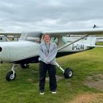
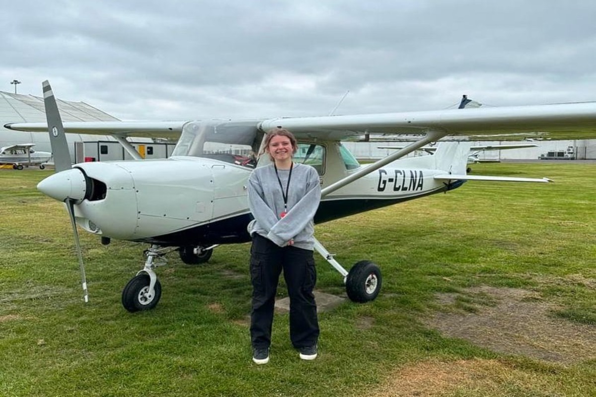
I flew in the aircraft I intended to use for the challenge, a C152 with extended range fuel tanks. The purpose was to fly to an unfamiliar airfield outside of my comfort zone.
This is why I picked Beccles, an airfield about 20nm to the south-east of Norwich, and a few miles inland of the coast. It has always been an airfield that I found somewhat intimidating. The combination of its short, mixed-surface runway and the parachuting activity conducted from the site made it a good airfield to push me outside my comfort zone.
Beccles’ runway is around 2/3rd tarmac and 1/3rd grass with the TORA for runway 27, the most used runway direction, being 690m and the LDA 562m, if the grass is available. If the grass is closed, both the TORA and the LDA for 27 is reduced to 445m. The runway is shorter than any airfield I was planning on visiting on my challenge, and about the same width as the smaller airfields on the list. The grass section gave me the opportunity to practice my soft field landings and take-offs.
I took a qualified friend with me who had visited Beccles previously. As this was my first flight to an alternative airfield in over a year, having someone familiar with the site provided additional reassurance and support should I have needed it. Beccles turned out to be a welcoming and straightforward airfield, and I left feeling significantly more confident in my abilities and reassured that I could undertake my flight solo.
Three days before the planned flight
Three days before the planned flight, I completed a solo general handling flight which included steep turns, practice forced landings, basic navigation and several touch-and-goes. This was to primarily make sure I felt comfortable flying, landing and communicating with nobody in the plane, because although I had been PIC a few days prior, it had been about 10 months since my last solo flights.
Alongside the practical flying preparation I did in the days running up, long-range weather forecasts were consistently checked from the Met Office, and other sources.
Navigation Preparation
From experience, I’ve found that I prefer having physical versions of plogs and airfield plates on my kneeboard. I like to minimise the number of screens turned on when I’m flying (only having SkyDemon running on my phone). So, I printed Pooleys plates for every airfield I intended visiting and highlighted in bright pink on each of the plates major information I may need at a glance, such as preferred joins, un-towered hours, etc.
I then organised these into four plastic sleeves:
- Group 1: Cambridge & Turweston
- Group 2: Oxford, Gloucester & Wellesbourne
- Group 3: Halfpenny Green, Tatenhill, Leicester & Connington
- Group 4: Old Buck, Seething, & Duxford
The primary goal was organisation. This system meant that at each full-stop landing, I could change sleeves and ensure that the required plates for the next leg were easily available, not damaged, and in the correct order. This meant that if I needed to divert to a previous airfield, I would know exactly where to find the relevant information.
I went a step further by printing aerial images of the 12 airfields from Google Maps. On each image, I highlighted the most likely join onto the airfield and took note of what the major reference points look like from above. Because I was unfamiliar with many of the destinations, this additional preparation was intended to help me build a mental picture of each airfield before arrival. With such short intervals between some of the planned stops, there would be little time to study unfamiliar layouts while airborne. Having already considered what I should expect to see, this would help reduce the risk of becoming disorientated or overwhelmed during the joining procedure.
The day before
I went into the airport and confirmed the aircraft had enough hours left, the date of its next inspection, that the tech log stated no known defects and that all the legal documents were in date.
I then began arranging PPRs for the planned airfields, prioritising Oxford and Gloucester as they are slotted and busy airfields. I knew that any issues or any changes that would need to be made would be because of those two airports. Oxford provided the slot that I had requested, however Gloucester told me that they were unable to accommodate a touch-and-go due to staff shortages and could only give me a landing slot at 11:00, and then a departure at 11:15. This would require me to land, taxi around the airport, hold, then depart again, adding time and complexity to my schedule.
I continued arranging the remaining PPRs online, with the exception of Turweston & Duxford, which are phone only and I decided I would call in the morning alongside Old Buckenham and Leicester, both of which didn’t have a notes section on their PPR page and I would confirm I only required a touch-and-go. I ended up completing seven paper plogs. I knew how chaotic the morning was going to be, so I completed these the day prior using forecast winds to calculate timings and ground speed, and used these calculations to help me make the decision for fuel pick up along the flight.
The primary weather concern would be the cloud base. The wind was forecast to be around 5 knots, with no more than 10 knots throughout the day. The enroute TAFs for early to mid-morning the next day stated as follows:
- Stansted showed cloud few at 3000ft, probability 30% cloud broken at 1200ft between 03:00 and 08:00.
- Luton showed similar at cloud scattered 3000ft, probability 30% between 02:00-09:00 with Mist, shallow fog, 6000m visibility and showery rain.
- Mildenhall showed light rain, cloud few at 5000ft, cloud broken at 10,000ft, becoming between 08:00 and 09:00 scattered 4000ft.
- Birmingham showed cloud few 4500ft and probability 30% between 06:00 and 08:00 8000m visibility.
- Fairford showed 8000m visibility, mist, cloud scattered 2000ft, cloud broken at 5000ft.
Cambridge is located in-between Mildenhall and Stansted, so taking a rough average of these TAFs suggested that I would have issues departing at my ideal time of 0845. Alongside this, Fairford is relatively close to my first two stops, Turweston and Oxford, making their forecast of mist and low visibility concerning. Although the predicted weather was worse than ideal, I stayed optimistic and continued preparation.
Because of how the weather was looking, I packed an extra overnight bag with a spare set of clothes and toiletries. This was just in case the flight went ahead but I got stuck somewhere due to weather, aircraft issues, or personal circumstance. Alongside this, mass and balance was completed using the highest airfield elevation which was Leicester at 469ft (rounded up to 500ft) and the warmest temperature of the day at 20 degrees. Landing and take-off performance is significantly worse at higher altitudes and warm temperatures due to reduced air density, causing less propeller thrust and therefore requiring more runway. I wanted to make the worst situation possible so that no matter what, I knew I could make any of the runways. Some of the shorter runways such as Seething and Old Buckingham, I would land, backtrack, then take-off. Because I was heavy, and it was forecast to be an abnormally warm October day, I wanted to maintain an appropriate safety margin.
The Morning Of
The first thing I completed was a vital self-evaluation, IM SAFE. This is simple, but incredibly important for any flight, especially on a long solo flight such as mine.
- I – Illness – do I have any symptoms? Do I feel generally well?
- M – Medication – Am I taking any over the counter medicine? Any pain killers of any kind?
- S – Stress – Are there any pressures or feelings of stress that could affect my performance?
- A – Alcohol – Have I been drinking within the past 24hrs?
- F – Fatigue – Am I tired or not adequately rested?
- E – Emotion – Am I stressed or in destress?
I then checked TAFs for the day, to which Stansted showed between 08:00 and 09:00 becoming cloud few 300ft, with reported 8000m Visibility. This was less than ideal, but I arrived at the airport at 07:40, checked out the plane, and checked the NOTAMs, both of which were looking good. Because I was using a C152 with extended range fuel tanks, filling the tanks up completely would’ve placed the aircraft outside mass and balance for more than one occupant. Because I was already apprehensive that the flight would go ahead, I made the decision to not fuel the plane at this point.
Focusing initially on the Met Office’s F214 and F215. The F214 low level spot wind chart showed winds from a westerly direction between 10 and 15kts. This wasn’t a huge issue, as most of the runways were roughly westerly, there were only two or three that would have a more prominent crosswind component. The F215 low level weather forecast showed a mostly clear day, with potential for low cloud and poorer visibility.
VFR at or below 3000ft AMSL requires staying clear of cloud and in sight with the surface. So, I can fly above cloud as long as I stay in sight with the ground, but when approaching airfields, clouds need to be above circuit height. Because of the vast number of airfields that spanned over such a large area, all with different circuit heights and terrain heights, this would cause further challenge.
Cambridges METAR was encouraging, between 07:50 and 10:20 the lowest cloud reported was few at 1900ft, but the clouds were lifting overtime. The wind was no more than 11 knots, with the TAF showing 10k+ visibility, cloud few at 2000ft and no more than 9kts of wind throughout the day.
Oxford and Fairford highlighted the most issues. This time of year, crystal clear days are usually accompanied by patches of low fog in the morning that burn off by the afternoon. Oxford showed clouds broken 200ft to 300ft between 06:50 and 09:50. Even later between 10:20 and 10:50, which is more like the time I would’ve landed, Oxford showed clouds few at 1200ft, which is below their circuit height of 1500ft. With Turweston being situated close to Oxford, I was apprehensive to depart Cambridge with those poor weather conditions. Oxfords TAF wasn’t looking ideal either, with probability 30% of 6000m visibility.
Furthermore, Gloucester was showing clouds few at 2500ft at 09:00, which seems very high, but my minimum safety altitude around that area was 2300ft. METARs show a snapshot of weather at a particular time and therefore wasn’t an exact representation of what is occurring. Because terrain towards Wales is so high, any track adjustments westwards could’ve placed me below my safety altitude. At my intended departure time from Cambridge, Gloucester was reporting few clouds at 1600ft, while its TAF included a 30% probability of visibility reducing to 6000m.
Shawbury is the closest Meteorological reporting station to Wolverhampton Halfpenny Green. They were showing clouds few at 1600ft with the cloud only really starting to lift around 11:00. Birmingham showed similar reports.
All these forecasts suggested that conditions to the west were unacceptable in the morning, but would improve in the afternoon with CAVOK conditions and 10kts of wind. It was clear that a clockwise departure was no longer a viable option.
A possibility was to do the route backwards in an anticlockwise direction. One of the benefits of going east first would be the low terrain, meaning a lower safety altitude. This could’ve made the initial low cloud that covered certain areas of England less of an issue, and because the cloud was gradually lifting, when I would fly over the areas of higher terrain to the West, the clouds would be higher, therefore I’d be able to fly higher and maintain that separation.
Marham was showing low cloud, with few at 1000ft and slowly lifting up to 1800ft at around 10:00. This routing was appearing to be more achievable than the original plan.
However, by the time I had properly considered the alternative and assessed its implications, I was well past my original departure time, which wouldn’t have been such an issue in the summer months, but sunset was forecast for around 18:30. Although I have a night rating, I intended to do this flight fully between the hours of dawn to dusk. By around 09:15 I had effectively reached a conclusion.
The final decision came down to the weather around Oxford. It wasn’t clearing up, and it didn’t look like it would for an hour or so, by at that point the limited daylight became a more prominent focus.
Although I could potentially have shortened my stops at Turweston, Wellesbourne or Connington to recover some time, I did not want to sacrifice the breaks I had built into the schedule. I scheduled these from a fatigue-management perspective, I knew they would be critical on such a long and demanding solo flight.
Changing the route would’ve also required amendments to all the PPRs I had booked. Contacting each airfield would’ve taken time, and due to Oxford and Gloucester’s busyness, it isn’t certain that later arrival slots would’ve been available
Alongside all of this, the aircraft still needed refuelling, I needed to book out of Cambridge, update the technical log and obtain authorisation from an instructor. These tasks would have added further delays at a point when the available daylight was already becoming a limiting factor.
Altogether, the weather, operational constraints, and diminishing daylight meant that proceeding would’ve required too many compromises. Due to the extensive planning that went into this flight it was disappointing that it did not go ahead, but I knew that safety and my own comfortability was more of a priority. I do intend to complete this flight next year once the weather becomes more reliable again, and I have the time to put all my focus on it.